|
Darton is a village in the Metropolitan Borough of Barnsley (part of South Yorkshire, England), on the border with West Yorkshire. At the time of the 2021 UK census the population of Barnsley was 227,000, the Darton wards of Darton East and West contributed a population of 21338 to this total.
The name Darton is believed to be an amalgamation of "Dearne" and the Anglo-Saxon word "ton" (meaning 'town'). Hence, in ancient times it was known as 'the town on the Dearne'. However, other sources dispute this explanation and claim that the name originates from a description given to a deer enclosure or something similar.
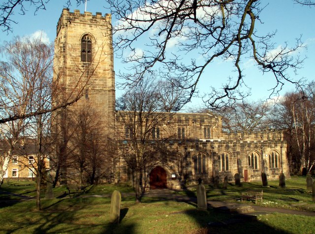
A church was built in the village in 1150, but an official register of baptisms, deaths and marriagesdid not begin until later, in 1539. The parish was historically within the West Riding of Yorkshire and became a part of the former county of South Yorkshire upon its creation in 1974. did not begin until several centuries later in 1539.
|
 |
|
Nearest Town is Barnsley, a town in South Yorkshire, England. It lies on the River Dearne, 11.8 miles (19 km) north of the city of Sheffield, and 14.5 miles (23 km) west of Doncaster. Barnsley is surrounded by several smaller settlements which together form the Metropolitan Borough of Barnsley, of which Barnsley is the largest settlement and administrative centre. Barnsley has a total population of over 227,000 (Cenus 2021). Historically a part of the West Riding of Yorkshire, Barnsley is notable as a former industrial town centred on coal mining and glassmaking. Though these industries demised in the 20th century, Barnsley's local culture remains rooted in this industrial heritage; Barnsley has a tradition of brass bands, originally created as social clubs for its mining communities. Today, Barnsley is commonly referred to as "The Tarn" by many of its residents. Access to Darton is at junction 37 of the M1 motorway and A637 Barnsley to Huddersfield road. Darton has a railway station served by the Hallam and Penistone Lines. Barnsley F.C. is the local Association Football club Barnsley F.C. Association Football club
|
See our site Map Via this Link
Summer Floods 2007
Site Created and Maintained by Anthony Gough
If you have a complaint against this website or any of its content
please read the Legal Disclaimer
Other Sites like this:
www.Mapplewell.org.uk
www.cawthornevillage.com
|
|
MAPS OF DARTON SINCE 1897 CLICK HERE
FIND US ON GOOGLE, Darton'S COORDINATES ARE:
53 deg 35 mins 11 secs N, 1 deg 30 mins 9 secs W
 OLD PHOTOS OF DARTON OLD PHOTOS OF DARTON
Advertisements

Go domains is the new way to buy domains choose the domain you want, send me an email, pay via Paypal and fast transfer to an existing Godaddy account all in a blink of the eye - special offer today is Staincross.com yours for £100 or maybe choose One Barnsley.co.uk@ £50
|